The big, cream-coloured male bear paced with us along the shore, not more than 50 metres from where I crouched in the bow of the inflatable boat. With his poor vision we were a fuzzy outline, but the outboard engine's low thrum warned him interlopers were just offshore. Awestruck by his size and raw power of his movements, the thing I remember now was the hope that if he decided to charge, my boat driver could get us out of there in a big hurry.
On the third day of our voyage through the Northwest Passage aboard the Russian-arctic cruise ship M.V. Akademik Ioffe, we sailed into Coningham Bay. Our expedition leaders told us there was a possibility we would see polar bears here, but no one expected them.
Late in the afternoon, our ship sailed out of Iqaluktuttiaq (Cambridge Bay) to carry us from the western end of the Passage to Greenland in the east. Aboard there were more than 90 passengers who had signed on with WorldwideQuest's Alumni Expedition to experience what travel writers are now calling “The New Everest.”
I'm not sure about it being the “new Everest.” Our cabins were a lot more comfortable than wind-blown tents in the Himalayas, and the only way to undertake this adventure is with an experienced expedition company.
The Northwest Passage has held a fascination for anyone who has spent time studying Canadian history and knows the story of Sir John Franklin's ill-conceived attempt to traverse this ice-choked sea passage in 1845.
Franklin set sail from England with two ships and a crew of 133 men and what was considered to be state-of-the-art equipment. His were among the first steam-powered ships, with cabin heating provided by the boilers and seawater made drinkable by distillation from the engines. They also carried more than 1,000 books to keep the crew and officers entertained and three years worth of preserved and canned provisions.
Then they were never heard from again, except for a brief note found in a cairn.
Our adventure begins when passengers and staff fly north from Edmonton to Iqaluktuttiaq aboard a chartered Canadian North 737.
None of us were prepared for the moment the door on the plane opened. Late summer made us forget we were heading into a cold climate where winter is in perpetual motion. One moment you can have brilliant sunshine with near-balmy temperatures, and the next the weather can turn, developing a blizzard faster than Vancouver can spawn a rainstorm.
At the Cambridge Bay Airport, we were offered the choice between walking into town to shake the kinks out or riding in school bus taxis. With most of my cold weather gear buried deep in my suitcase, I opted for the ride option.
The bus was slow enough to get a good look at the land. There wasn't a tree in sight. I kept reminding myself that we had left the tree line and Arctic Circle an hour-and-a-half to the south.
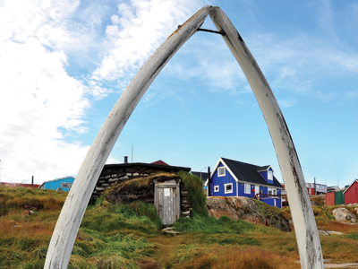
Once into the town though, the welcome was warm. Cambridge Bay and the Canadian Arctic are working hard to make themselves a tourist attraction for adventurous travellers. Tourism is so new here, the cultural performances are homegrown rather than slick productions. The town's community centre ““ the Luke Novoligak Katimavia Centre ““ was staged for cultural performances and lunch.
This is where we really understood we weren't in Southern Ontario anymore. The way of looking at things and daily expediencies were entirely beyond our ken. On the presentation table our hosts had laid out the skin of a polar bear. “It's just a small one. My husband shot it last spring because it came into town and wouldn't go away again.”
I thought the bear looked rather large and wouldn't want to meet him while taking out the trash.
Cambridge Bay is small by southern standards, a population of about 1,400, but here in the Arctic it's metropolitan. Its Inuk name means “good fishing place,” which tells where priorities lay. However, there is a new library/school and a state of the art medical centre ““ even an electronic pedestrian crossing sign. Roads are unpaved because maintaining a paving in this climate would be impossible and once the snow lies permanently on the ground snowmobiles don't need established tracks.
Just offshore, the Akademik Ioffe waited for us. To get to her, we had to transfer by Zodiac inflatable boats. First though, we made a run past a barely submerged shipwreck. These were the remains of Roald Amundsen's ship, Maude. She was built by Amundsen to study ice drift in the Arctic.
Unfortunately for the Maude, Amundsen was a trickster and hustler who had a habit of bamboozling his investors. When he succeeded, by being first through the Northwest Passage and the first to reach the South Pole, he was forgiven. But when things were not, his creditors wasted no time in foreclosing on his debts. This was the fate of the ship named for the Norwegian Queen in 1925 in Seattle. Too stout not to go back into arctic service, the ship was purchased by the Hudson's Bay Co. and rechristened Baymaud.
Eventually she sank at Cambridge Bay in 1930. Plans are now afoot to refloat the embarrassed wreck and tow her back to Norway where engineers will decide whether to restore her or preserve as a historical display along with Amundsen's other vessels ““ the Gjoa and Fram.
Akademik Ioffe's first stop after leaving Cambridge Bay was Victory Point on King William Island and we sailed all night to get there.
Victory Point at Cape Felix is an important part of the Franklin story. We were scheduled to go ashore here because this was where the southern-most remnants of the Franklin expedition were found and from which ghostly tales among the scions of British society began to emerge.
The wind was up and seas too contrary for a landing, so the expedition's Zodiacs (these also served as transport to and from landings) could not land. After two cold and wet hours, the boats returned to the mother ship and we headed north again to Prince of Wales Island and the bears.
Polar bears are rightly given the Latin name Ursus maritimus because they are the only bear to spend most of its life on sea ice and in the water. They live on a diet of seals, whales and fish. In Coningham Bay, from the number of whale skeletons strewn about, it appears they are highly successful at taking beluga whales that come into the shallows there.
This is where I see my first wild polar bear. He's a big male ambling along the slope of a ridge higher up the shore. Up comes the telephoto lens, but Mr. Bear is half a kilometre away and, between the pitch and yaw of the boat and his shambling gate, I succeed in recording a furry white blotch in my frame.
Just as I'm about to throw the camera overboard in disgust, the boat's radio crackles with the news that a female with two cubs was seen swimming across the bay toward our shore.
From that point onward our boat spots more than a dozen of the white bruins ““ upwards of 20 are finally reported. At supper the talk was about nothing but bears.
During the evening expedition leader Boris Wise let us know we would have to travel most of the Bellot Strait that runs between Somerset Island and the Boothia Peninsula joining Peel Sound to Prince Regent Inlet at night in order to catch the tide.
By morning we exited the strait named for its discoverer, Joseph René Bellot, the French officer who joined the international search for Franklin. At the eastern end of the strait, the winds were calm and we were able to go ashore at Fort Ross, an abandoned Hudson's Bay Co. trading post.
The fort ““ if you could call it that ““ consists of two frame buildings, a flagpole, a fallen-down radio antenna and a cairn which reads: “This cairn has been provided by members of the McClintock family in proud memory of Admiral Francis Leopold McClintock ““ the discoverer of the fate of Franklin ““ 1859.”
Fort Ross was established in the 1930s by the HBC and staffed until 1947. There was a factor (the man in charge of the post) and his assistant. They were the only Europeans. Visiting Inuit provided some relief from the closeness brought about by the isolation, which was a direct result of sea ice.
At one point the two young men received no communications or supplies for three years because ships couldn't penetrate the ice-choked Gulf of Boothia to reach them.
To visit the site we made a wet landing on a gravel beach. Getting your feet wet is not an option in this climate and so our cumbersome gumboots were mandatory.
First off the boats were our gunmen. As soon as they determined the area was clear of bears, we landed.
The exteriors of the buildings still had some of their original paint clinging to the weathered boards. I was delighted with the front yard of the main house. It was a carefully groomed semi-circle with stone borders.
In the field leading up to the houses, empty oil drums and rusted food cans littered the ground. Some of the food cans had mouth-shaped teeth punctures in them from scavenging bears.
In the kitchen of one of the houses, an oil stove leaned at a slatternly angle having two of its legs rusted through so the right side collapsed onto the floor. Behind it, remarkably preserved, was an entire wall of homey wallpaper featuring teapots and bread plates. Was this HBC's attempt at fostering a sense of home or did somebody haul the decorative rolls all the way up here to stave off winter's madness?
If there's a place on earth where the dead roam the landscape, it's in the Arctic.
There are four graves and the decaying Northumberland House supply shed on Beechey Island that testify to the naí¯veté of Franklin's attempt to find the way through the Passage.
Three of those graves contain Petty Officer John Torrington, Royal Marine Private William Braine and Able Seaman John Hartnell. The fourth belongs to a searcher who died in the vain effort to locate the expedition.
These were the only members of Franklin's original expedition to be identified. Other skeletons and bits of bone were found along the route they took south from here revealed a grizzly truth. Knife marks found on these remains tell a story of survivors seeking one more day of life by eating their fellow explorers and that in the end these gentlemen sons of England were no better or worse than the rest of us.
We can't go ashore on Beechey. Bears have been spotted near the graves but they are close enough to the shore for us to see and photograph them.
Leaving the tragedy behind, our next landfall is Pond Inlet on Baffin Island. To get there we ploughed all night through a growing field of sea ice that threatened to stop us. The Akademik Ioffe is built for this and we made it through.
Pond Inlet is a fishing village situated on the northern tip of Baffin Island and surrounded by spectacular glaciers. The French Arctic cruise ship, La Boreal was also in town. Ours was a short stop here and after a walk through town to the community centre for more cultural performances and shopping before re-boarding our vessel for another overnight cruise to Gibbs Fjord on the central Baffin coast.
Following standard procedure for going ashore we first checked for bears and confirmed there were none. What we did see was splashing and small plumes of spray from a pod of about 20 narwhals.
They were in the shallow end of the fjord and close enough to the shoreline that I could see electric blue streaks as they swam past me underwater. Attuat, our Inuit resource person with the expedition said, “the reason they look blue like that is that they're swimming upside down to scrap their backs on the gravel bottom to help peel molting skin.”
When they weren't cavorting on the gravel bed, they came to the surface to breath. I was expecting to see the famous “tusk” which is really a long tooth, but these were females and their calves; not bulls with their unique dental growth. It's very rare to see narwhals at all and to see this number so close was a once-in-a-lifetime event.
Boarding the ship again, we set sail for Greenland ““ two days away across a storm-tossed Baffin Bay. Our first stop on the world's largest island was Ilulissat. Whalers have been using this safe harbour to over-winter and as a supply base for almost three centuries. It is also the birthplace of explorer Knud Rasmussen whose birthplace is now a museum dedicated to the Greenland culture.
Greenland is Danish and the town reflects this. The inner harbour could be Copenhagen, and although most of the population is Inuit, they speak with a lovely, singsong Danish accent.
Ilulissat is also situated on the Jacobshaven Fjord ““ birthplace of most of the North Atlantic's icebergs. Because the waterway leading to the face of the glacier that spawns these is choked with new calved bergs, we can't get close enough by boat to see the actual process. Still, the neighbourhood-sized blocks of ice are impressive enough and this is where the iceberg that sank the Titanic in 1912 was born.
Getting home required sailing south to Kangerlussuaq where Greenland's international airport is located. Even though we had just spent two weeks in a world apart, the flight home from this European outpost took a scant four-and-a-half hours.
If you go
The Northwest Passage is accessible only with a certified expedition company. I travelled with Toronto's WorldwideQuest on this voyage. But, you can visit all towns in the Canadian Arctic on your own with direct flights.
Nunavut Tourism
nunavuttourism.com
Cambridge Bay Tourism
cambridgebay.ca/visitingus/visitors
Pond Inlet Tourism
explorenunavut.com/pondinlet-tourism.php
WorldwideQuest
worldwidequest.com
1.800.387.1483